


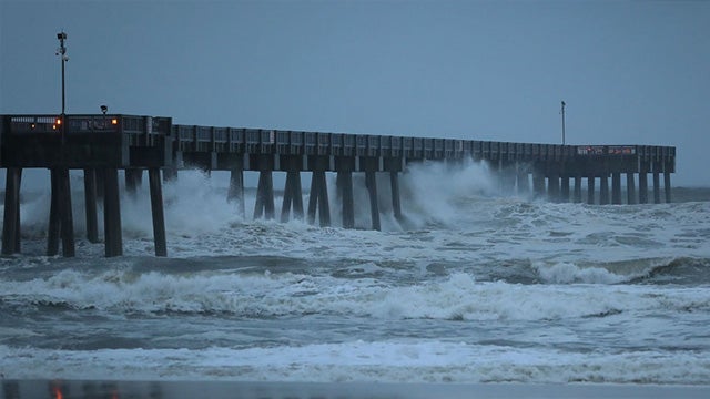
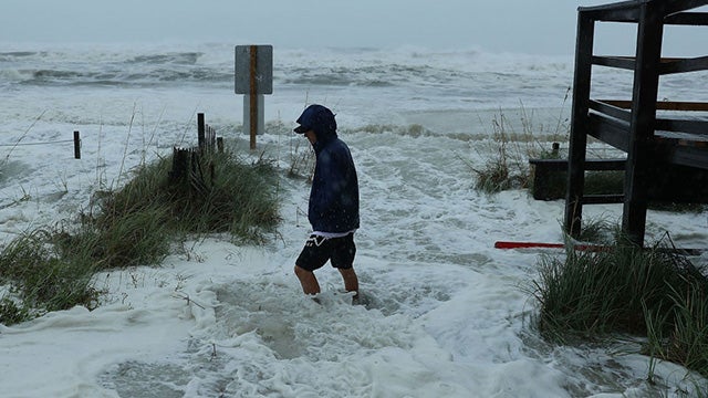
RUSH: I was told today that even the Weather Channel has evacuated their crews out of Panama City, Panama City Beach. I wouldn’t blame ’em. I think it’s ridiculous to stay out there and stand in the streets when a Category 4 is coming. The winds are now 150 miles an hour, and everybody is genuinely scared to death of this one. This one, it seems is different in terms of how everybody’s talking about it. All eyes currently fixed on Hurricane Michael.
It is going to devastate the Florida Panhandle, Category 4. That puts winds anywhere from 130 to 156 miles per hour. Storm surge (which is the primary killer in hurricanes, by the way) is nine to 14 feet at the… That’s not… Don’t think of a storm surge as a tsunami. They’re two different things. Tsunami, sometimes you can’t even feel it. A tsunami’s not a gigantic wave. A storm surge is, and people get the two confused. It’s a big eyewall.
It is well established. It’s not weakening. It’s continuing to strengthen. It’s gonna have a swath all the way up through Georgia. The way I look at it, it’s gonna hit Atlanta, then Augusta, and on into South Carolina, and right through the middle of North Carolina, and it’s gonna be dumping rain like crazy. The only thing different here is that this thing is not gonna stop and hover for a couple of days in the same spot.
It’s moving at a pretty rapid clip, which is the only thing you can say about it. Now, there was a bunch of previously damaging hurricanes. There’s all kinds of misinformation out there, and it’s because of the corruption of news. People are trying to report today, “We’ve never had a Category 4 hit the Florida Panhandle.” It isn’t true. There have been all kinds of major hurricanes that have hit the Florida Panhandle.
Experts have studied sea sediment and lake and river sediment and have found that hurricanes probably hit this region a thousand years ago, when nothing was there and nobody was there. Certainly nothing there to damage. There was a hurricane that hit in a similar location back in 1906, and it wiped out everything from Mobile to Panama City, but there wasn’t much to wipe out. There wasn’t much infrastructure then.
So it’s crazy to start comparing financial damage with hurricanes of many, many years ago to today because this region was not nearly as developed with infrastructure and homes and businesses as it is today. The degree of damage that this storm is going to cause is immeasurable. But people are beginning to look at it as a rebuilding opportunity and a chance to, you know, build it all over again. But you cannot miss the devastation that’s coming with this.
The governor, Rick Scott, says he’s scared to death about this. There’s no stopping it. There’s nowhere for people to go, and the evacuation plans have been underway for a while. Some people in condominiums and apartments are not leaving! They’re gonna stay there. There are those people that want to stay and live through one of these, primarily to see if it’s really like everybody says it’s gonna be. There’s a curiosity among some people.
You watch the news, you watch TV, and they tell you how devastating it’s gonna be, how destructive it’s gonna be, how much rain there’s gonna be, how “you can’t survive it” it’s gonna be. And they say, “I want to stay and see this!” And then there are others who say, “I want to stay and I’m gonna protect my home. I’m gonna hang in here with my homestead. I’m gonna stay here with my pets. I am not leaving; you can’t kick me out.”
So there will be some people who will hang on and stay. Now, this area is properly known even among the locals as the Redneck Riviera. In modern political parlance, it means a bunch of poor, white-privilege people live there. The Drive-Bys are surprisingly interested in this. I say, “surprisingly,” because there’s not a central major population center that can be totally wiped out, that they could equate with, “See? See how dangerous global warming is?”
But there is a midterm election coming up, and there is going to be a federal response to this — and as far as the media’s concerned, there’s an opportunity. The federal response won’t be any good and so they can call this Trump’s Katrina. Don’t get mad at me for talking about this, because I’m telling you right now that is exactly how assignment editors and producers throughout the Drive-By Media are looking at this.
They’re looking at this as a potential political event that they’re hoping might be somewhat helpful to them in the midterms elections that are only three weeks away. There is a heated governor’s race in Florida. Mayor of Tallahassee, Andrew Gillum, running against Ron DeSantis. And then Rick Scott, the current governor, is running for the Senate against the incumbent, Bill Nelson. So there’s a lot politically at stake here.
You can’t deny it, folks. And you can’t… You cannot ignore the way the media is preparing a bunch of different scenarios to report on this. It’s got the global warming component. That’s No. 1. As a Category 4, 150 miles an hour, there’s lots of destruction — human destruction as well. It’s got all the ingredients there. It is the Republican voting stronghold of the state in the views of many. (interruption) No, no.
Look, you can get mad at me all you want. I’m just telling you: I know the media. You may think it insensitive of me to be speaking this way. I’m not. I’m telling you how they in the Drive-By Media are planning, and they’ll react at some point. Little Brian Stelter will go out there, “I can’t believe that these kinds of things are being said about us in the imminent danger of the storm!” I’m just telling you, it won’t be long to find out.
This hurricane kind of came out of nowhere. It was little tropical storm down of the primary tobacco-growing area of western Cuba known as the Vuelta Bajo. Then it sprang to life as a Category 1, and the National Hurricane Center said, “You know, this thing is looking very bad.” Nobody was paying much attention to it, and then all of a sudden it’s a Cat 3 and it’s making a beeline for Panama City and Panama City Beach — and here we.
The media is now focused on this. Do you think, Mr. Snerdley…? Do you think there is — and I know it’s gonna sound crazy. But do you think the Drive-Bys might be looking for a bit of a respite from all this Kavanaugh stuff and…? (interruption) You don’t think so? And you don’t think the hurricane is providing just a momentary opportunity for…? (interruption) Oh, I know they hope it turns into Katrina for Trump. I’ve just… And Kavanaugh. They hope it turns… And Rick Scott, of course.
They want it to turn into Katrina for every Republican involved here.
BREAK TRANSCRIPT
RUSH: And all eyes remain fixated, once again, on Hurricane Michael. This next 45 minutes to an hour will tell the tale in terms of the actual landfall. It’s gonna be anywhere from Mexico Beach up to Panama City northwest along the coastline. Mexico Beach, I think is what it is, all the way up to Panama City, then Panama City Beach. But this eyewall, according to all of…
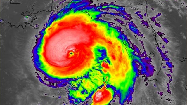
And I’ve got some fascinating satellite photography here from the GOES-16 satellite. It’s interesting the way they do this. You know how they take the radar and they attach different colors to it. And what I’m looking at is sheer, solid black surrounding the eyewall, and most of the black is on the south and the west side. And then it gets a little lighter, then some gray, and then dark red, and then bright red, and then yellow, and then tan, and then orange, and then green, and then blue on the edges.
Now, these colors do not represent rain intensity. They represent cloud tops. They represent the temperatures at the cloud tops, which determines condensation and can determine intensity of rainfall. But most people watching this have no idea. They think, “Oh, my God! Look at that, Mabel! Look! It must have been a hundred miles per hour. Look at that! It’s black — black, right around there. Dark red.” It’s designed to scare you. It’s designed to get your attention.
It’s cloud-top temperatures. But my point is, it’s solid around the eyewall. It looks like the most intense area of this is due west of the eyewall, which is where the population centers are based on where the eyewall looks like it’s gonna hit now. But even on the east side… The east and northeast quadrants are where the strongest winds are, and those are gonna be blowing offshore — toward offshore — once they hit land on the northeastern side of the eyewall.
 But it’s a solid eyewall, and it’s a large eyewall. So it’s a very, very intense storm, and the next 45 minutes it’s gonna hit land, and then we’ll know where and the speed with which it will continue, the amount of rain and storm surge. So it’s gonna be a very, very bad bunch of days and intense, bad few hours here for people who live in that region, the Panhandle of Florida.
BREAK TRANSCRIPT
RUSH: Pressure is dropping in the hurricane. That’s not good. It’s now 35 miles south-southwest of Mexico Beach, which is what I think the closest populated landfall area could be. But that’s just my wild guess. One thing about these storms: They’re reporting winds at 150 miles an hour, and they just showed neighboring cities and what the wind gusts are. The highest wind gust right now around 64, 65 miles an hour in the Panama City, Panama City Beach area.
These 150-mile-an-hour winds are in the eyewall, folks. They are not the entire storm. I’m not trying to minimize the impact here. It’s just the reporting on these storms and the education on these storms in general is, I think, wanting; it’s lacking. Such as the way they colorize the graphics of these storms to make it look like hell on earth, when in any hurricane the strongest winds are in the eyewall and a little, you know, extended from it.
But there’s not too many places they’re gonna get 150-mile-an-hour winds today. Where the eyewall hits and maybe 20 miles, depending on the size of the eyewall. Now, from there it will fall off. Nothing… I mean, 125 is no slouch. If you think that you’ve experienced 75-mile-an-hour winds and say, “Well, that’s not bad. I can…” The effect of 150 versus 75 miles is not twice when you’re in it. There is a multiplier effect of massive wind speed.
So if the fastest and the highest winds you’ve been in is 75 miles an hour and you think, “Okay. A Cat 4 is gonna double this,” it won’t. On the ground, miles per hour it is. But the impact of 150-mile-an-hour winds versus 75? Just destructive capability alone is a factor of three or four. So 150 miles an hour is dead serious. That’s where the storm surge will be or the worst of it. The further you get from the eye and depending on the structure, the more the wind speed decreases.
The rainfall is pretty consistent throughout a much larger area of the storm. But the devastating winds, the worst winds of the storm are only in the eyewall area. People can look at these storms and the graphics, “Wow, 150 miles an hour… Oh, winds all…? That’s all…? It’s the whole Panhandle.” No, it isn’t. I’m not trying to downplay the damage. I’ve just learned all this. We live in Hurricane Alley here, and every time one of these things…
I moved here in 1997, and I quickly became a consumer hurricane expert. I became an expert in how to interpret and watch the media. I became an expert in how to analyze the graphics that they use, and I became an expert in where the actual worst damage of a hurricane is. You do not want to get a direct hit. Everybody says, “Yeah, of course, Rush. Everybody knows that.”
Yeah, but outside the direct hit the damage or the strength of the hurricane diminishes quite a bit. It’s always the direct hit that is the most destructive, and then it starts to decline as you get away from the eye, depending upon the strength of the storm. Is gonna have a wide, destructive swath as a Category 4. Here’s Governor Scott of Florida. This was this morning, a press conference, audio sound bite No. 1. Just to give you a taste of how local officials in the governor’s office are dealing with this…
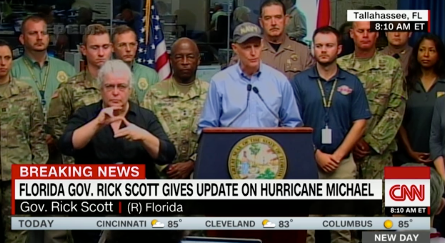 SCOTT: I just spoke with the president, who, again, offered all available federal resources. We continue being in constant contact with FEMA and their team in the state Emergency Operations Center. That includes experts from Homeland Security, the EPA, the Department of Defense, Health and Human Services, and the Army Corps of Engineers. Along our coast, communities are going to see unimaginable devastating.
RUSH: Unimaginable devastating. There’s a little hype always in this to get people to listen, to get their attention. But there’s always a lot of hype in these things. And, as an expert, a local resident expert, I can tell you that people who live in these areas for a long time have heard this over and over again, and very rarely are these storms as bad as they predict. So people, over the course of time, adopt an attitude and whereas, “Yeah. They’re making it worse than it’s gonna be for whatever reason, trying to scare everybody and get ’em to evacuate or what have you.”
People deal with these in different ways who live in areas and have experience dealing with them. Now, there have been four major hurricanes in the two years of the Trump presidency. And not a one of them, outside of this mess in Puerto Rico — not a one of them — have the media been able to label Trump’s Katrina. They’ve tried in advance. They have not been able to. It seems the prep’s good here too.
BREAK TRANSCRIPT
RUSH: By the way, here’s the calculation on the force of wind versus wind speed. Remember, the force of the wind does not does not double as wind speeds do. The force increases in a much greater rate, and there’s a formula that scientists have developed. The force of wind goes up as a square of speed. So two times… If you’ve got 30-mile-an-hour winds that will all of a sudden become 60, the force of that would be much higher, say two times…
You would square the 30. You’d get… No, you’d get close to hundred-mile-an-hour force when you get above the 75-mile-an-hour limit is what it really is. So the two times wind is four times the force of the wind. Three times is nine times. You square the speed to find out what the force of the wind is. So 150 miles an hour, it’s devastating. Now, where do those winds happen?
Are those surface winds? Are those flight-level winds? And this is what you have to have the Hurricane Hunter data to know. But they are reported as winds on the surface, 150-mile-an-hour winds at the surface. I mean, there’s very little that’s gonna survive that. So we’ll see exactly what at landfall the true wind force, the wind speed happens to be and find out how close to the forecast it was.Now, look, this is a minor technical point. I’m probably gonna get in trouble for making it. There is a tweet here from the National Weather Service calling this storm the worst-case scenario. But it isn’t. It’s a Category 4. It’s not… The eyewall doesn’t look like it’s gonna hit a major population center. Now, do not misunderstand me. I am not saying it isn’t a big deal. A worst-case scenario would be Category 5 barreling right over Panama City or Panama City Beach.
This thing looks like it’s gonna hit between or has hit between Panama City and Mexico Beach. Mexico Beach is such a small place that you have to expand the map to times 10 before it reads out that there’s a city there. This is basically a wooded area, not heavily populated, but Tallahassee’s right down the road from where this thing is gonna hit.
Now, this does not mean that Apalachicola and Pensacola and Pensacola Beach and Panama City Beach are not gonna get hit. They are. But not by a worst-case scenario. I had to look… It’s a minor point. It’s no comfort to people in the zone here. It’s just, again, I’m a stickler for the way things end up being reported. People get all ginned up and worked into a frenzy over things, particularly in politics, and usually is not warranted.
And it’s in this way that media and others so successfully manipulate people, whereas people that try to play it straight and deal with it honestly and straight on are a bit of a disadvantage.
BREAK TRANSCRIPT
RUSH: Hurricane Michael now 155-mile-an-hour sustained winds, gusting to 175. This is at the eyewall. This is at the area of landfall, which is not far from Mexico Beach, up the coast of Florida Panhandle, about 15 miles west-northwest. The president today had a briefing with his FEMA people and Homeland Security people and as he is wont to do, he televises the briefings. One of the reasons he does it is so that he can let the media and everybody see what goes on at a cabinet meeting, what goes on at some other special meeting. This was the president being briefed by Homeland Security Chief Kirstjen Nielsen and the FEMA administrator, Brock Long, but Hurricane Michael.
THE PRESIDENT: They’re reporting that this is one of the most powerful hurricanes ever to hit our country. Is that actually a fact?
LONG: In the are, this would be the most intense hurricane that struck this area since 1851, if I remember correctly, so —
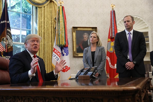 NIELSEN: It’s a big storm.
LONG: Yeah. Intense. Very intense. But —
THE PRESIDENT: And this one is gonna be heavy rain or is it gonna be the winds that are gonna be the brunt of it?
LONG: Storm surge and winds, and for Georgia they’re gonna see high inland winds; so you may see sustained Category 1, Category 2 winds with higher gusts. We’re expecting a lot of damage inland as well.
RUSH: This is President Trump with the FEMA director and Homeland Security Secretary Kirstjen Nielsen being briefed on Hurricane Michael in the Oval Office. Here’s more.
THE PRESIDENT: Almost the entire size of the Gulf. When you look at it topically, it’s almost the entire size of the Gulf, and they haven’t seen that… Maybe they haven’t seen that at all. Nobody’s seen that before.
LONG: The eye diameter is pretty wide, which, unfortunately, is not good news as it makes landfall. So some people may say it’s similar to an EF3 tornado making landfall in the areas that are close to the eye.
RUSH: I’m glad this guy said close to the eye. That’s where… When you read about the high winds and the rain, that’s where the brunt of it is. Now, this storm is so strong that it’s bad as you get away from the eye. But the real bad stuff is the eye. This eye, I think I saw 30 miles… No, no. It’s not that big. Now that I’m looking, not that big. The smaller it is, the more intense, usually. And, as usual, it’s the north and western quadrants here with the wind speeds speeding up and heading in that direction. Here’s one more bite with the president still with the FEMA director and Homeland Security.
THE PRESIDENT: We don’t know. I was going to Pennsylvania. It looks like there are thousands of people already lined up, and probably we’ll do that tonight and we’re gonna go down here as soon as we can. We don’t want to interfere with anybody but we want to go as soon as possible. You have… You know, right nearby we have thousands of people going tonight, and they’ve already… Many are there already.
RUSH: Now, a lot of people… I get some emails when this stuff happens. “You know, you’re falling for it, Rush. It just approves what a suck-up you are. Trump’s not doing this for any other reason than he just wants to brag. He’s just doing this for PR.” No, friends. You may think that, and I’m not gonna try to disabuse you of it. But the president’s doing this because if he didn’t, can you imagine the stories that would be published?
“Trump doesn’t care! Trump didn’t convene a meeting! Trump didn’t ask very many questions! Trump didn’t seem curious! Trump doesn’t seem to have any real interest since he doesn’t have a home there.” All this kind of stuff that they would say about him. He does this for a host of reasons. But most importantly, I believe, Donald Trump likes himself, and he’s very proud of the job he’s doing, and he wants people to see it. And he knows that the primary conveyors of information in this country do not convey properly information about him.
This is only smart.
 BREAK TRANSCRIPT
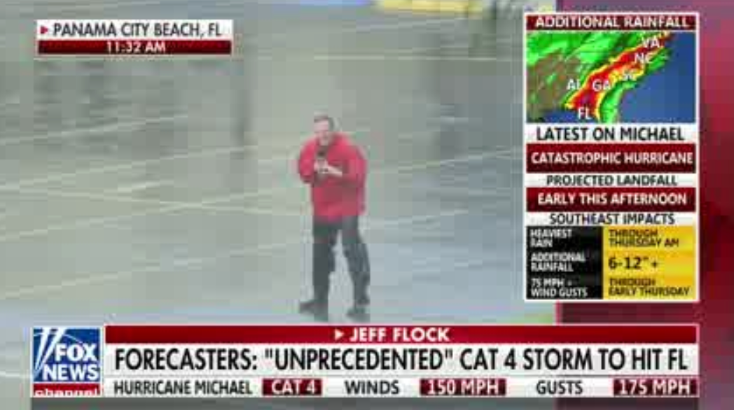
RUSH: I was just watching a little bit of Fox News. They got a reporter out there standing in the middle of all this hurricane. His name is Jeff Flock. He was telling Shep, said, “Shep, you’ve been out here like I’ve been out here. Shep, I tell you, we’d much rather cover man versus nature than man versus man any day,” and Shep said, “Oh, oh, yeah. That’s absolutely true.” My heart melted. I almost… I almost broke down.